


Gps


Thread Starter
Senior Member
Joined: 02-01-2006
Posts: 1,471
From: lockport,ny
Gps
I don't know if this belongs in the audio and video forum. If it does then please move it there.
I did a search and most of the GPS info was from a few years ago. Since new models come out pretty regularly, I am hoping to get more up to date info.
We are getting ready for a long family car trip (3K miles) and I would like to buy a GPS. The trip will not be in our 2 HHRs but the eight of us in our Suburban (2002 K2500 8.1L).
I am good with regular maps, the main reason I want one is for the Points of Interest feature so we can find gas stations, McDonalds, etc on the road.
I have a few questions:
Is the traffic feature worth the extra cost and does it really work well? I assume this feature warns me about traffic jams/accidents ahead so I can avoid them.
Is the 5" screen worth the extra $ over the 4.3" screen?
Is the extra $ for bluetooth worth it?
Any recommendations for a specific model? It seems the Garmin gets the best reviews. I am also trying to keep the cost down and don't need the latest and greatest version. I have found new 5" Garmins with lifetime maps and traffic for about $125. Then there are 5" Garmins with lifetime maps and traffic all the way up to $250+. What do the more expensive ones get me?
Thanks for the help.
Steve
I did a search and most of the GPS info was from a few years ago. Since new models come out pretty regularly, I am hoping to get more up to date info.
We are getting ready for a long family car trip (3K miles) and I would like to buy a GPS. The trip will not be in our 2 HHRs but the eight of us in our Suburban (2002 K2500 8.1L).
I am good with regular maps, the main reason I want one is for the Points of Interest feature so we can find gas stations, McDonalds, etc on the road.
I have a few questions:
Is the traffic feature worth the extra cost and does it really work well? I assume this feature warns me about traffic jams/accidents ahead so I can avoid them.
Is the 5" screen worth the extra $ over the 4.3" screen?
Is the extra $ for bluetooth worth it?
Any recommendations for a specific model? It seems the Garmin gets the best reviews. I am also trying to keep the cost down and don't need the latest and greatest version. I have found new 5" Garmins with lifetime maps and traffic for about $125. Then there are 5" Garmins with lifetime maps and traffic all the way up to $250+. What do the more expensive ones get me?
Thanks for the help.
Steve

Platinum Member
Joined: 04-09-2006
Posts: 7,043
From: Vancouver, BC, Canada
I don't think you can go wrong with a Garmin - TomTom is real popular up here - Magellan less so.
A 4.3' screen works well in the HHR as it will still be fairly close to you, and a 5" you might find to be a bit obtrusive at times. All mine are 3.5" units and they work just great, and are small enough to drop into the door pocket when not in use.
Yeah, go for Lifetime maps for sure - as otherwise updates are very pricey, and maps do go out-of-date to the point where you will notice a difference after a year or so.
I have never gone for the traffic option - not sure how useful that would be, especially up here.
Bluetooth - might be handy for your cell but you would have to try it. A friend had one with Bluetooth from Garmin, but he found it wasn't that great - maybe "perfect' would be the right word. That is something you would have to try in your vehicle I think as they would likely work different depending on the vehicle and where you have it located.
If you buy one, make sure you remove it, or at least hide it when you are not in the car - they are high theft items.
A 4.3' screen works well in the HHR as it will still be fairly close to you, and a 5" you might find to be a bit obtrusive at times. All mine are 3.5" units and they work just great, and are small enough to drop into the door pocket when not in use.
Yeah, go for Lifetime maps for sure - as otherwise updates are very pricey, and maps do go out-of-date to the point where you will notice a difference after a year or so.
I have never gone for the traffic option - not sure how useful that would be, especially up here.
Bluetooth - might be handy for your cell but you would have to try it. A friend had one with Bluetooth from Garmin, but he found it wasn't that great - maybe "perfect' would be the right word. That is something you would have to try in your vehicle I think as they would likely work different depending on the vehicle and where you have it located.
If you buy one, make sure you remove it, or at least hide it when you are not in the car - they are high theft items.

Moderator
Joined: 01-23-2009
Posts: 26,533
From: Fredericksburg,VA
My Android phone cost $50 + $45/ month on VirginMobileUSA 1200 minutes unlimited text unlimited data (3g and they throttle after 2.5 GiB).
It runs Google Maps (don't upgrade, the newer versions will crash the phone). Navigation uses the latest Google maps and traffic, it gives me brutally precise drive times.
You could also try MapQuest (free) or Sygic (has a free version), they both seem good as well. All of them have good POI (that's who pays for it).
It runs Google Maps (don't upgrade, the newer versions will crash the phone). Navigation uses the latest Google maps and traffic, it gives me brutally precise drive times.
You could also try MapQuest (free) or Sygic (has a free version), they both seem good as well. All of them have good POI (that's who pays for it).

Senior Member
Joined: 04-22-2009
Posts: 763
From: Southern California
As others have said, android phones navagation works quite well. I also have an older Garmen, which was high end when I bought it, about six or seven years ago, and has voice input. I find that really usefull when programing while underway, I can just talk to it. It also does have the traffic feature, so I get that yellow triangle with the number of minutes of traffic delay. I find that interesting, but rarely use the bypass traffic option, as it will often put you on some pretty horrible surface streets. I have lifetime map updates with the garmin, and have to say I have been veryt satisfied with it. At six or seven years old, its still very useful, and works well. It also has bluetooth, but other than to try it when I first got it, I never use its bluetooth. I would probably go for another Garmen if I were in the market for a new GPS. I really do like the voice command option, use that a lot.

Moderator
Joined: 01-23-2009
Posts: 26,533
From: Fredericksburg,VA
If data is a problem, there is a "make available offline" option on Google Maps. It is not very obvious.

Senior Member
Joined: 02-21-2010
Posts: 537
From: Burlington, ON
I used to use a GPS until I got an Android phone with Google Nav.
WAAAYYYY more acurate with times and WAYYY higher detail level.
When I call a client and say I'll be there at X oclock I like that time to be within a few mins.
I did a month of side by side comparison testing .
Typical example : GPS to destination said 15 mins Google Nav said 45 mins in a city I know all too well.
I got there in 40 mins. Even Google tries to keep you on the "straightest " or shortest route. But first hand knowledge of the streets and traffic saved me a few mins.
With Google in many citys you can zoom in and see "real time" traffic and see green yellow red and very dark red marks on the various routes.This sometimes will show you routes that I would have taken despite Googles insistence to go the other way.
For POIs on Google you need to enable your location settings and everything Google knows about in your area or if you zoom in to a destination should be seen.
If you do use a GPS Do NOT try to beat my high score!!
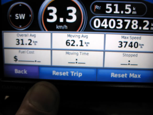
If it matters the GPS was a Garmin and sold to a smartphoneless guy for the battery.
My "testing" was done 3 phones ago. Currently using a NOTE 3 with Android version 4.4.2
WAAAYYYY more acurate with times and WAYYY higher detail level.
When I call a client and say I'll be there at X oclock I like that time to be within a few mins.
I did a month of side by side comparison testing .
Typical example : GPS to destination said 15 mins Google Nav said 45 mins in a city I know all too well.
I got there in 40 mins. Even Google tries to keep you on the "straightest " or shortest route. But first hand knowledge of the streets and traffic saved me a few mins.
With Google in many citys you can zoom in and see "real time" traffic and see green yellow red and very dark red marks on the various routes.This sometimes will show you routes that I would have taken despite Googles insistence to go the other way.
For POIs on Google you need to enable your location settings and everything Google knows about in your area or if you zoom in to a destination should be seen.
If you do use a GPS Do NOT try to beat my high score!!

If it matters the GPS was a Garmin and sold to a smartphoneless guy for the battery.
My "testing" was done 3 phones ago. Currently using a NOTE 3 with Android version 4.4.2
Last edited by Fox Hat; Apr 18, 2014 at 09:21 AM.
Thread Starter
Senior Member
Joined: 02-01-2006
Posts: 1,471
From: lockport,ny
Thanks for the advice, everyone.
I do have a smartphone, but its an older model with a small screen (Motorola Defy XT). I got it last year (one for me one for the wife) because Republic Wireless was offering a good deal (buy phone for $200, then $19.95per month for unlimited voice, text, and 3G data).
What I will do is try using the smartphone locally as a nav device to see if it works OK.
Steve
I do have a smartphone, but its an older model with a small screen (Motorola Defy XT). I got it last year (one for me one for the wife) because Republic Wireless was offering a good deal (buy phone for $200, then $19.95per month for unlimited voice, text, and 3G data).
What I will do is try using the smartphone locally as a nav device to see if it works OK.
Steve

