Deja Vu Rendezvous '09 / May 9, 2009


Senior Member
Joined: 11-23-2007
Posts: 2,202
From: Inland Empire, CA.
Okay just in case we make it up there at a decent hour, what time and where are you all meeting on friday night? I'm shooting for around 7 traffic and fire? (didn't know there was one) permitting.

Senior Member
Joined: 09-10-2008
Posts: 508
From: Long Beach
Senior Member
Joined: 09-10-2008
Posts: 508
From: Long Beach
So far the evacuation boundries are about 3/4 of a mile east of hwy 154 (the eastern leg of the route) we will have to wait and see what the weather has install for the area on Thursday & Friday, as it sit's right now it's open, but that could change in a hartbeat. and a change of wind direction...
Here is a link to the latest evac and fire map:
http://maps.google.com/maps/ms?ie=UT...,0.241013&z=12
Here is a link to the latest evac and fire map:
http://maps.google.com/maps/ms?ie=UT...,0.241013&z=12
Senior Member
Joined: 09-10-2008
Posts: 508
From: Long Beach
If the 101 is closed,,,,,,, BUMMER!
Alternate route #1: 246 Mi. 4hr 59min or up to 6hrs 40min w/traffic
http://maps.google.com/maps?f=d&sour...=UTF8&t=h&z=11
Alternate route #2: 254 Mi. 5hr 26min or up to 6hrs 50min w/traffic
http://maps.google.com/maps?f=d&sour...e=UTF8&t=h&z=8
Alternate route #1: 246 Mi. 4hr 59min or up to 6hrs 40min w/traffic
http://maps.google.com/maps?f=d&sour...=UTF8&t=h&z=11
Alternate route #2: 254 Mi. 5hr 26min or up to 6hrs 50min w/traffic
http://maps.google.com/maps?f=d&sour...e=UTF8&t=h&z=8

Senior Member
Joined: 09-14-2007
Posts: 3,365
From: SoCAL & Louisville, KY
At this point I am still a "no" -- especially with alternative routes that could get me to San Francisco in the same time frame (5-6 hours from OC on the grapevine). Since I would have gone up for the day only, too long of a day for me.
For those who go, still sounds like a good time!
@
For those who go, still sounds like a good time!
@

Thread Starter
Senior Member
Joined: 02-07-2008
Posts: 826
From: Lakenheath, UK
okay everyone, does anyone have any ideas for a backup plan? i know there are a few people coming in and staying for a few days, and it would be a real shame if we had to totally cancel, but at this point, thanks to JRACERX's linked fire map, it appears it's a REAL possibility this fire could put a major hurt on the cruise route. we have today and tomorrow to hope for some kind of containment or preventative measures to cease westward movement, otherwise we're SOL. unfortunately i'm in the middle of my work week, and don't have a lot of free time to try and plan out another event for us to do instead. unless everyone wanted to meet up for breakfast or lunch, and do a group tour of the motorcycle museum or something? with the entire SB area threatened, that really cuts down on what we can do. only other option would be a QUICKLY cobbled together cruise route that takes us more north, but there isn't much for beautiful views that way, nothing like the original route.
feel free to toss in your thoughts. and c2vette, if you see this, any ideas?
feel free to toss in your thoughts. and c2vette, if you see this, any ideas?

Senior Member
Joined: 09-10-2008
Posts: 508
From: Long Beach
It's looking a little better, looks like the Evac area has moved east and a little south. The Fire looks to be about 3 miles North of the 101
Source: (L.A. Times)
Calmer 'sundowner' winds give firefighters a break in Santa Barbara:
Fire officials battling the Santa Barbara blaze said "sundowner" winds that fueled the destructive blaze have been much calmer today, providing firefighters a needed break. As of 7 p.m., the blaze was 10% contained, officials said.
The National Weather Service issued a high-wind warning for the Santa Barbara coastal area, predicting winds of 40 to 58 mph at times through Friday morning. The warning covers Santa Barbara, Montecito, Carpinteria and San Marcos Pass. Gusts could reach 65 mph
http://maps.google.com/maps/ms?ie=UT...6902cc1ed7baa8
Senior Member
Joined: 09-10-2008
Posts: 508
From: Long Beach
Looks OK so far
Source: (Cal Trans)
This highway information is the latest reported as of Thursday, May 7, 2009 at 19:37 .
US 101
[IN THE SOUTHERN CALIFORNIA AREA]
NO TRAFFIC RESTRICTIONS ARE REPORTED FOR THIS AREA
This highway information is the latest reported as of Thursday, May 7, 2009 at 19:59 .
SR 154
[IN THE CENTRAL CALIFORNIA AREA]
NO TRAFFIC RESTRICTIONS ARE REPORTED FOR THIS AREA.

Senior Member
Joined: 11-27-2007
Posts: 1,115
From: Austin, Texas
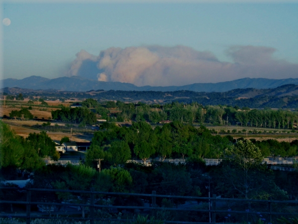
Amazing how big this plume got in just the last 2 hours (big winds) this is a view from the Santa Ynez side of the mountains. Weather should be nice and cruise should not be affected by this fire other than possibly going through SB on 101 freeway. Check SR 154 also before you head out. Listening to mandatory evacs near Foothill and 154 right now, but it is still open.